.pdf
.pdf
Context
Axessim
Axessim is a company specialized in electromagnetic simulations. The company is dedicated to developing cutting-edge tools tailored for conducting electromagnetic simulations, with a specific focus on the "Maxsim" software. This versatile tool employs the Finite-Difference Time-Domain (FDTD) method to solve Maxwell’s equations for electromagnetic simulations. Axessim has also integrated several other programs into its portfolio, including "Mustard," which facilitates the conversion of non-structured meshes into structured meshes, "Temsi-FD", a finite-difference solver developed by the University of Limoge, and "Kawa" designed for analyzing simulation data.
Psol Project
During my internship, I contributed to the PSOL project. This project is a collaboration between Axessim, Thales and the XLim (University of Limoge).
Objectives
It aims to model terrestrial communication in real-world of environments, in the context of military operations. The type of communications that is considered includes long distance communication based on HF radio, and short distance communication based on VHF and UHF radio.
Name |
frequency (Wave length) |
High Frequency (HF) |
3-30 MHz (100-10 m) |
Very High Frequency (VHF) |
30-300 MHz (10-1 m) |
Ultra High Frequency (UHF) |
300 MHz - 3 GHz (100-10 cm) |
Challenges
The main challenges this project is addressing includes the modeling of the propagation on Earth’s surface, the complexity of the prediction and the complexity of the electromagnetic environment.
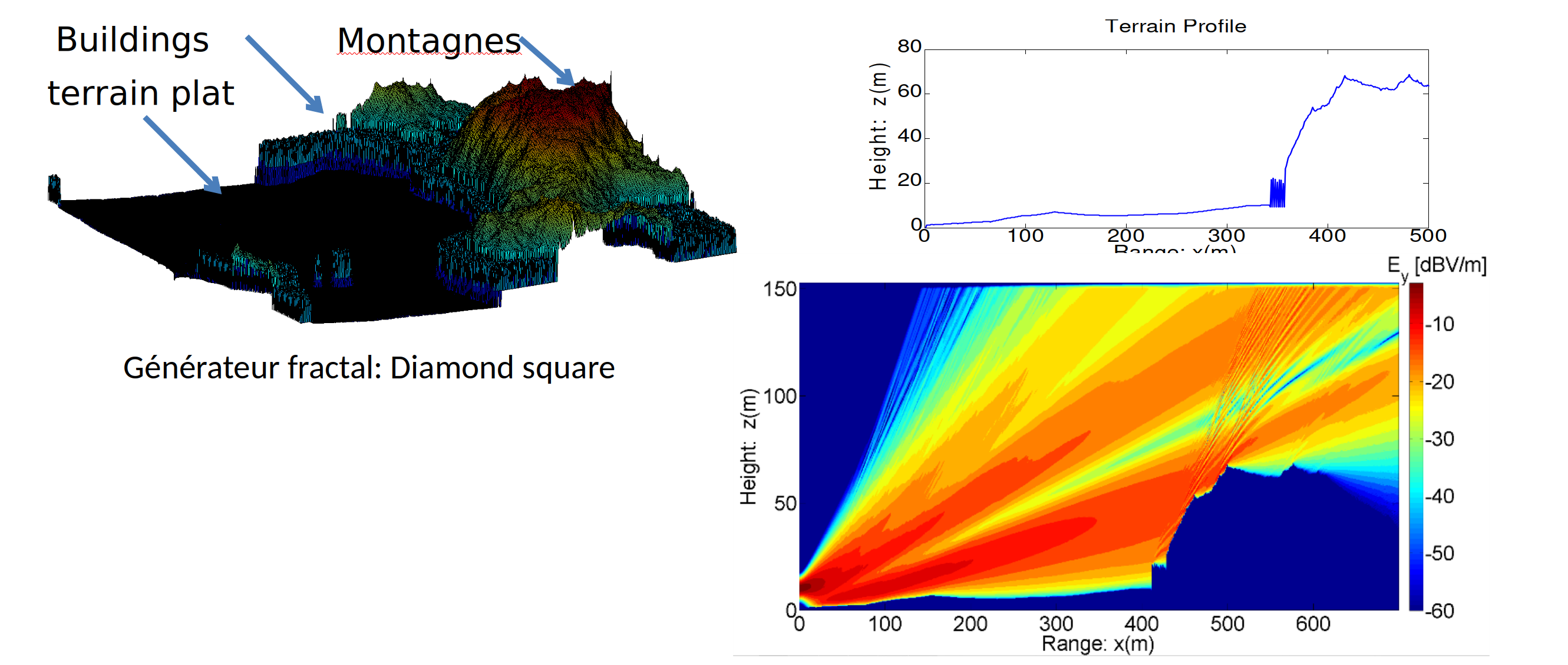
The propagation on Earth’s surface is a complex phenomenon because the surface is not flat and is composed of different types of materials which impact notably the propagation. In a previous project XLim evaluated the impact of mountains on the propagation radio waves in the HF domain (figure 1). The simulation was done using the one-way wave equation which is a simplified model of the propagation. In the test case bellow, the emitter is position at point . We can see that the mountains diffract the wave and create a shadow zone behind them.
The complexity of the prediction is due to the fact that the simulation of surface wave requires the resolution of the Sommerfeld equation which involves an integral over the surface. The size of the scene will be of the order of square kilometers and should be mesh with a resolution of the order of centimeters for the UHF. This combined with the resolution of the Sommerfeld equation makes the problem computationally expensive.
Another challenge is the complexity of the electromagnetic environment. The battlefield as evolved to include more and more electronic devices communicating with each other. This creates a lot of interference and makes the prediction more difficult.
Actors
Each actor has a different role in the project. Axessim is in charge of the generation of the scenes. This includes the generation of the terrain and the above ground objects as a structured mesh to be used by the FDTD solver.
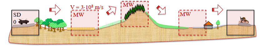
XLim improve its FDTD solver to be able to simulate the propagation using moving windows (figure 2).
Thales will provide experimental data to validate the simulation.
Previous work
In a previous collaboration with Axessim, I developed a tool that can generate models of the Earth’s surface based on remote sensing data and classify the surface into different types.
Digital Elevations Models
Digital Elevation Models (DEM) are a digital representation of the Earth’s surface. They are used in a wide range of applications which involves the study of natural phenomena interacting with the surface of the Earth such as hydrology, geology and civil engineering. They are also used in the simulation of radio wave propagation. The DEM is a grid of elevation raster. Each cell of the grid contains the elevation of the surface at the corresponding location.
The DEM are subdivided into two categories: DSM and DTM. The DSM (Digital Surface Model) represents the elevation of the top of the surface. The DTM (Digital Terrain Model) represents the elevation of the bare ground.
The DSM is obtained by remote sensing techniques such as LiDAR (Light Detection And Ranging) or photogrammetry. The DTM is obtained by removing the vegetation and the buildings from the DSM.
In my previous work the data from the IGN (Institut National de l’Information Géographique et Forestière) which is the French national mapping agency were used. The data is available for free on the IGN website and divided into several datasets.
-
RGE ALTI : Référentiel Géographique à Grande Echelle (RGE) contains data on the elevation of the terrain (DTM). The data are obtained by photogrammetry, ALS and on-ground measurement. The resolution is 1 meter.
-
MNS Corélé : Modèle Numérique de Surface (MNS) contains the elevation of the above ground features (DSM). The data are obtained by photogrammetry. The resolution is 0.5 meter.
-
BD TOPO : Base de Données TOPOgraphiques (BD TOPO) contains information on the position of the features on the ground. It gather data coming from various sources (land registry, classification of the aerial photographs, …).
Results
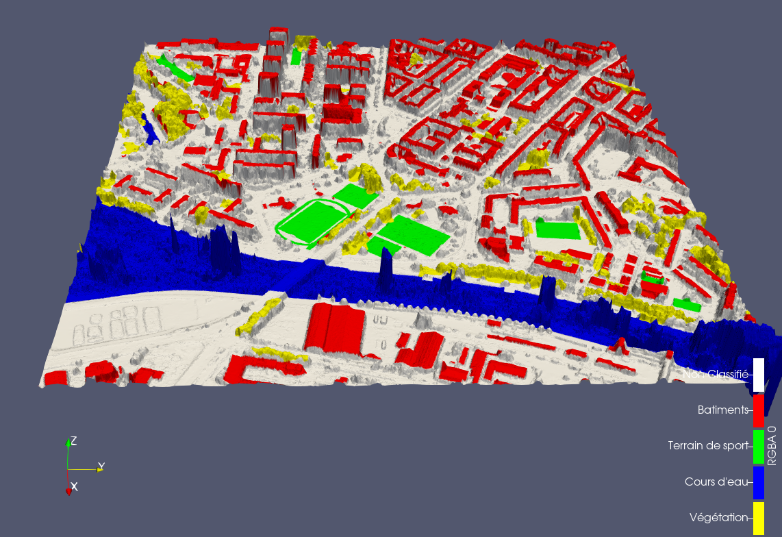
The tool I developed with Dieudonné Medessi is able to generate a model of the Earth’s surface based on the IGN data. The model is generated in the form of a Triangular Mesh.
The tool comported though several limitations that I should address during my internship. As once can see in figure 3, the DSM contains a lot of noise on the water. This is due to the fact that the DSM is obtained by photogrammetry which is has a low accuracy on repetitive or homogenous surfaces. Moreover, the trees are just represented by their crown. The model also fails to detect above water objects such as bridges or parts of the vegetation which are classified as water.